
Upcoming Hike on Thursday, June 25:
Rainbow Falls, NC Gorges State Park
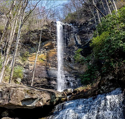
On June 25, Ed Blackburn will lead Holy Hikers through NC Gorges State Park on a trail that travels along the Horsepasture River then reaches Rainbow Falls. This 3.4-mile trail is rated moderate (not easy). It will be one of our more challenging hikes with an elevation gain of around 700 feet. Learn more about the trail here. We will not hike the entire trail to Turtleback Falls. Instead we will explore Rainbow Falls then return to a quiet location for lunch and liturgy. This will allow us a nice break before we embark on the last mile+ of the trail which is all uphill.
The park is part of a temperate rain forest and home to mosses that usually thrive in the tropics! That said, make sure to pack rain gear, use hiking poles and wear boots/shoes with good tread. Pack water and lunch or a snack. Dogs are allowed if leashed.
The trailhead address is Rainbow Falls and Turtleback Trailhead, Grassy Ridge Rd, Lake Toxaway, NC 28747. Plenty of parking is available. Click here for Google Maps.
Please plan to meet at the trailhead at 10:00am. The trailhead is about 43 miles from St. John in the Wilderness. Drive time is approximately 1 hour and 5 minutes. If you wish to convoy from the church, meet at the Parish Hall parking lot no later than 8:40am.
Directions from St. John in the Wilderness
Head toward Pinecrest Presbyterian on Greenville Hwy.
At the roundabout, take the third exit onto Erkwood Dr.
In 1.4 mi, turn left onto Kanuga Rd.
In 2.9 mi, continue straight onto Crab Creek Rd.
In 10 mi, turn left onto Everett Rd.
When you cannot go straight any further, turn left onto Old Hendersonville Hwy.
When you cannot go straight any further, turn left onto N Broad St.
In 0.4 mi, keep left to stay on N Broad St.
In 1 mi, take a slight right onto US-64 W.
In 17.6 mi, turn left onto NC-281/Whitewater Rd.
In 0.9 mi, turn left onto Grassy Ridge Rd.
Your destination will be on the right in 1.7 mi.
Save the Dates: 2026 Holy Hikes
January 14
February 26
March 26
April 23
May 21
June 25
July 23
August 16
September 24
October 25-28
(Retreat)
November (TBD)
December (TBD)